Case Study for GPS Data Collection for South Windsor, Connecticut Traffic Sign Inventory

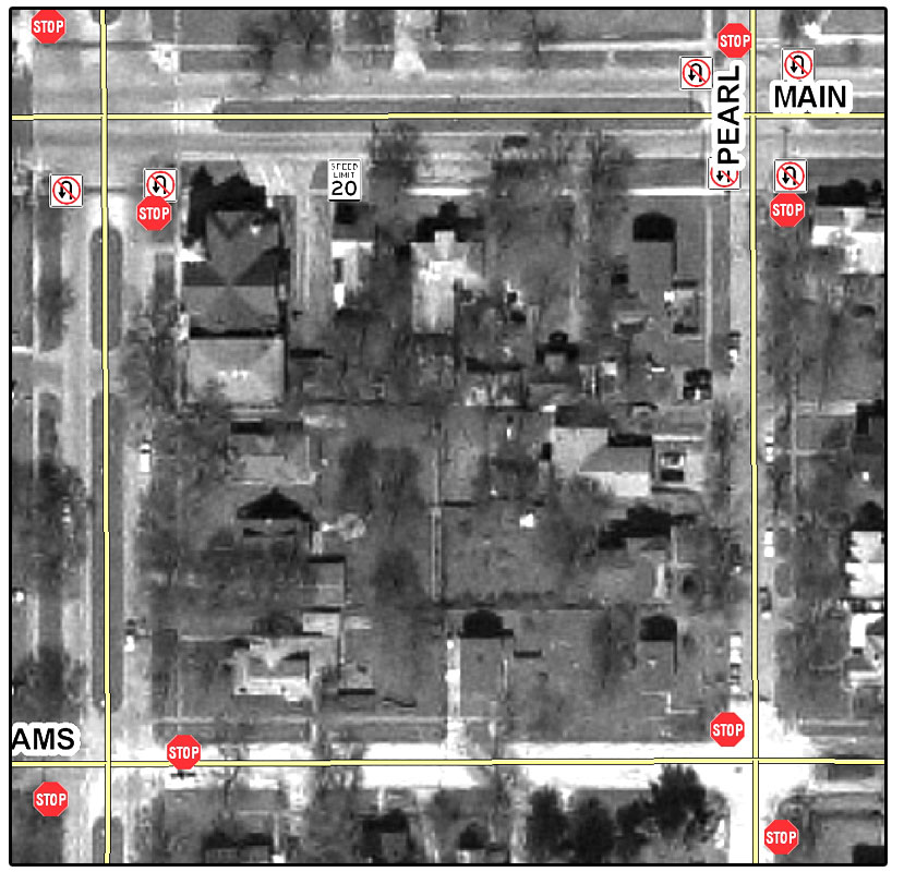
In the Spring of 2016, the Town of South Windsor, Connecticut contracted with Mid-West GIS to create a comprehensive Traffic Sign Inventory. While the town used GIS technology, they had no existing sign database, and they realized that the effort to create one in-house would take years, as well as resources they did not have available.

South Windsor is located in Central Connecticut, just north of the City of Hartford. It has a population of over 25,000 and was incorporated in 1845. The town has approximately 192 miles of road, and the project encompassed collecting all signs on roads the town maintains.
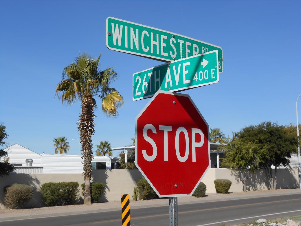
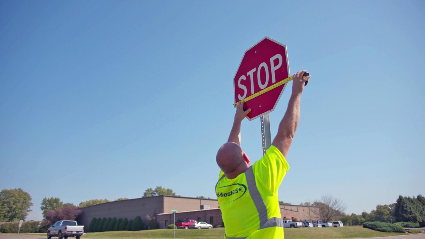
Data collection was done using a combination of handheld GPS data collectors, as well as mobile GIS technology using tablet PC’s with GPS capabilities for navigation and attribute collection. The handheld GPS was used to collect the GPS point and assign a unique identifier, and the tablet PC was used to collect the attributes for the sign and post, as well as collecting and hyperlinking a digital photo of the face of the sign to the GPS point. Tablets are used for the attribute portion as they are easier to type multiple attributes quickly, and have the digital photo capability.
The project had a very tight schedule, as the town was anxious to receive the data and put it into use as their official Traffic Sign Inventory. Data collection took under a month, including Quality Control and delivery. Over 4,200 GPS points were collected, as well as one photo for each sign. The project was delivered on time and on budget, and the client proved to be very happy with the final product.

I wanted to take a minute to thank you for your services in the collection of our street sign inventory. I was skeptical that you could meet the timeframe that you set to collect all our signs town-wide. But to my dismay, you were right on target. Your aggressiveness in getting the work (collection) done but with the attention to detail made for a great finished product. I have yet to find a report that I cannot produce to get the answers I am looking for. Our police department uses the program for incident investigations as well as determining locations where signs, such as speed limits, were never installed are warranted.

We couldn’t have developed a program such as the one you delivered using our in-house staff, we tried. It was too time-consuming.

Again, we thank you for your willingness to work with us, customize what we wanted, collect, analyze and test the data which allowed us to get to work the day we received the finished product. I am so glad we made this decision!!!

Scott Yeomans
Associate Manager
South Windsor Public Works
Street Services

Case Study for the City of Carrollton, Texas

Mid-West GIS was contracted by the City of Carrollton, Texas to create a comprehensive traffic sign inventory using GPS data collectors, and migrated into an ESRI personal geodatabase model. The project began in March of 2018 and was successfully completed by July 2018. The project entailed collecting over 1,200 miles of road in a city with a population of over 135,000 residents. Carrollton is located in the Dallas Metroplex in the great State of Texas.

It took Mid-West GIS approximately five months to Collect, Quality Control, and deliver the data to the city. There were over 20,000 signs collected, and over 20 different attributes documented. In addition, one digital photo was taken of the face of certain types of signs and hyperlinked to the GPS point.

With high traffic volumes the city posed the challenge of being able to safely and accurately collect signs on major arterial roads such as Beltline Rd running east and west. The city allowed the use of a side by side all-terrain vehicle equipped with slow moving vehicle signs, and amber safety light that allowed us to maneuver down the right away without slowing or interfering with traffic. This was much safer, and did not require blocking traffic at all. This will be incorporated into future projects that pose the same type of traffic challenges.

The project was delivered ahead of schedule, and the client was completely satisfied with the data that was collected. The data is now being used as the official sign inventory for the city, and used daily by GIS staff and sign maintenance personnel.

Mid-West GIS was contracted by the City of Texarkana, Texas to create a comprehensive traffic sign inventory

Mid-West GIS was contracted by the City of Texarkana, Texas to create a comprehensive traffic sign inventory using GPS data collectors, and migrated into an ESRI personal geodatabase model. The project entailed collecting over 388 miles of road in a city with a population of over 37,000 residents. Texarkana is located in the Northeast corner of the State of Texas, and has a sister city across the Arkansas border with an additional 30,000 residents.

It took Mid-West GIS approximately three months to Collect, Quality Control, and deliver the data to the city. There were over 13,000 signs collected, and 22 different attributes documented. In addition, one digital photo was taken of the face of each sign and hyperlinked to the GPS point.

The project was delivered ahead of schedule, and the client was completely satisfied with the data that was collected. The data is now being used as the official sign inventory for the city, and used daily by GIS staff and sign maintenance personnel.

Hannibal Board of Public Works Electric Distribution System Field Inventory

hbpw
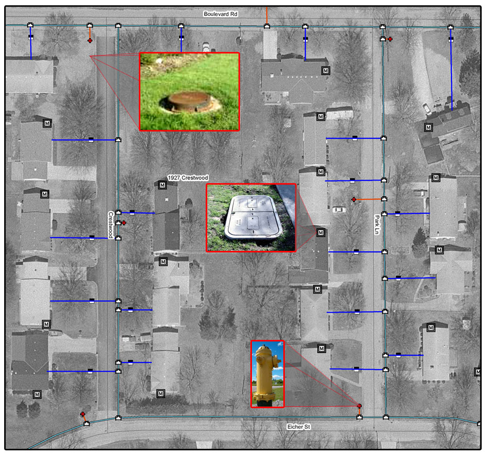
Mid-West GIS was contracted by the Hannibal Board of Public Works in 2012 to do a complete field inventory and update existing GIS data for their Electric Distribution System Utility Database. This included over 350 miles of line and 9,455 utility poles. The data had already been converted into a geodatabase, but needed field verified as well as additional data added that was missing.

It took Mid-West GIS approximately ten months to Collect, Quality Control, and deliver the final data set. Pole locations were corrected, as well as digital photos of each pole were taken and hyperlinked to the pole. Information on attachments and other assets were also documented.

Due to the complex nature of the utility model being used by the client, as well as their need to continue to have access to the data while it was being worked on, Mid-West GIS would field verify one sub-station at a time. Allowing for pieces of the data to be checked out of the system and worked on, while still allowing the client to use and manipulate other areas of the system.

The project was delivered ahead of schedule, and the client was completely satisfied with the data that was collected. The data is now being used by the client on a daily basis.

City of Apache Junction, Arizona Traffic Sign Inventory

Mid-West GIS was contracted by the City of Apache Junction to create a comprehensive traffic sign inventory using GPS data collectors, and migrated into an ESRI personal geodatabase model. The project entailed collecting over 180 miles of road in a city with a population of 35,000 summer residents, and over 75,000 winter residents. Apache Junction is a popular winter time vacation destination in the eastern suburbs of Phoenix.

It took Mid-West GIS approximately two months to Collect, Quality Control, and deliver the data to the city. There were over 7,000 signs collected, and 24 different attributes documented,. Mid-West GIS also implemented a sticker based bar code system for the city. This entailed placing a sticker on the back of each sign and documenting the bar code number in the attribute table. In addition, one digital photo was taken of the face of each sign and hyperlinked to the GPS point.

The project was delivered ahead of schedule, and the client was completely satisfied with the data that was collected. The data is now being used as the official sign inventory for the city, and used daily by GIS staff and sign maintenance personnel.

“Mid-West GIS was contracted to conduct a city wide sign inventory in winter 2014. The crews worked efficiently to complete the job in a timely manner and ahead of schedule. They were also very thorough and consistent in the data collected for each asset. During the inventory Shane and Joe kept in frequent contact to assure we knew the status of the project. Their many years of experience is evident in the product they provide. I would use them again for any future GIS or data collection projects and would highly recommend them to anyone.” Joseph Kliner GIS Technician City of Apache Junction, AZ

Central County 911 Addressing, St Louis, Missouri

Mid-West GIS was contracted in 2013 by Central County 911 in St Louis, Missouri to verify and correct addressing for approximately 3,500 linear miles of road centerlines. The Central County 911 Dispatch Center was taking over calls for both South County and North County, as those call centers were being closed. Therefore there was an extremely tight deadline for the data to be delivered so it would be tested and in place as they took over.

The project involved taking existing centerline data and adjusting not only the positional accuracy, but many of the addressing attributes as well. While there was some reference data that was useful, the project required GIS personnel to drive and physically verify every segment and every address in the project area. The entire project took approximately eight months, and was delivered on time and on budget. The data is now being fully implemented and used by Central County 911 for dispatching emergency calls.

“I have had the pleasure of working with Shane and his team at Midwest GIS on a large scale mapping project for Public Safety. Not only did they deliver high quality GIS data and services, but the team was very effective at understanding the specific needs of the project and meeting goals for both budget and timeliness. Their many years of direct experience and keen understanding of the challenges that come with leveraging GIS-based data helped guide the process and ensure that the data was reliable and put to good use. If you are contemplating any type of GIS project, I recommend that you reach out to Shane and avail yourself of his in-depth knowledge and experience to reach your goals! I can’t wait for the next opportunity to work with the Midwest GIS team!” Colleen Dealey, Project Manager.

City of Pampa, TX GIS Data Conversion

The City of Pampa, Texas GIS project is a complete GIS Data Conversion project. The City started off with no GIS system at all. The City budgeted for aerial photography and GIS data conversion services for 2008.

The first phase of the project, which started in February 2008, was to collect all Water Meters, Valves, Hydrants, Manholes, Sewer Inlets, Street Signs, and Trash Dumpsters with GPS equipment.

The second phase of the project was to convert the water and sewer lines into a digital format using the aerial photography and the GPS data collected in the first phase. Associated attributes are also added as the data is converted.

The final phase if the project is to install the software and data at the client site, and perform training necessary for the client to properly utilize the new GIS system.

Project Contact:
Donny Hooper Assistant Public Works Director

Mason County Sign Inventory

The Mason County Sign Inventory project is a cooperative effort between Mid-West GIS, Inc., Mason County Highway Department, the Illinois Department of Transportation, and eight of the nine cities and villages inside of Mason County, IL.

The project includes collecting GPS data and attribute information for all regulatory signs inside of Mason County. This information includes attributes such as location, type, condition, reflectivity, and other attributes. This inventory will then be converted into a report for the Illinois Department of Transportation, who will then evaluate the signs in Mason County.

Once the evaluation is complete, the Illinois Department of Transportation will provide new signs, poles, and hardware for all regulatory signs that are not up to code. The inventory located over 3,500 signs that need to be replaced at a cost of over $270,000. This project will save the county an estimated $225,000.

Contact Information:
Mike Pedigo, County Engineer
Mason County Highway Department